Some people may say I'm crazy, and some people may be right about that. I did manage to forget my camera this morning, but then I wasn't planning on this adventure. I kept looking out the window at work today, not a leaf moving, the flags drooping. I called the AWOS (automatic weather observation service) at the airport a couple of times, they said winds calm, etc., etc........ So, to make a short story long, this is what I did.
No pictures, but next trip up there I will get some evidence.
I left Phillips airport at 3:35 in the afternoon. I flew north hoping to get a better look at Superior since the sky was much clearer than the last time I went up that way. I was on a heading of about 340°, so I decided on 4500' altitude (going east{0° to 179°}you fly at odd 1000's +500. Going west{180° to 359°}you fly at even 1000's+500. This if for VFR flight...). ANYWAY, I flew over Park Falls and Butternut, both places I have flown before. I looked ahead for fields or other open places for possible forced landing spots(ya gotta thin' of that). They were few and far between, but looked do-able from that altitude. So I continued on and could see Glidden quite easily. The Penoke mountains were ahead a ways, but easily seen. Of course Lake Superior was in sight by this time, even from that altitude. If you have ever seen the area from Glidden to Mellen, it's pretty desolate. More so from the air..... but I pressed on, staying a few miles east of highway 13. Soon I was crossing the mighty Penoke range, a wide, fuzzy looking ridge that goes quite far east and west of the Mellen area. The Porcupine mountains were looking quite impressive from this point, too. I had to decide what to do at Mellen, as the area staight ahead toward the lake was pure forest, the Bad River reservation. So I needed to go either to the west, toward the Ashland area, or east toward Hurley. The western area looked more likely due to much more open area, but I didn't know about getting close to the lake in the Ashland area. If I went more easterly, I could follow some sparse areas of farmland and get to the lake sooner and away from Ashland city and airport. I decided to go east. The view of the lake was getting really fantastic at this point, and as I pressed on, I spotted US 2 winding along through the woods. Hurley was plain to see on my right. I dug out my sectional map and confirmed that the southernmost bay on the lake was indeed Saxon harbor. It was the closest point to me, so I headed for it. The map indicated that the land protruding into the lake just to the east of there was Little Girl Point. I remember my uncle Russ Mattson talking about looking for agates on the beaches there. I'll have to tell him about this trip! I noticed that there were VERY few cleared places north of US 2, but it was only about two miles from the lake, and I was now at 5500 feet after turning east at Mellen. The lake was looking awesome now. I noticed a grass landing strip out in the middle of nowhere, about a mile from the lake. Lucky bums.... By now I could not see land in front of the nose of the plane!! Woo-Hoo, I'm getting there! A few more minutes and the shoreline was nearly under me. I had a great view of the sand spit that runs out on the east side of Chequamegon Bay. The islands were not real distinct, but you could definitely tell you were looking at the Apostle islands. A little more altitude would have given a little better difinition of the islands, but what the hey??? I was now totally over the water. The different colors of the water in the lake was amazing. From sand color (runoff, I suppose) to light blues, sky blue and some really dark greenish/blue areas. I did a slow bank turn and headed southwest. I descended to 4500' again. It had taken 1 hour,20 minutes to get to the lake. Now I picked my way south, following any open areas below til I got to Mellen and crossed the Penokes again. What a beautiful stretch of country! I held my breath and crossed that mean looking area from Mellen to Glidden. At Mellen, I had turned more easterly and descended to 3500'. The rest was just a nice cruise home along familiar airways. I reached Phillips at 5:40P.M., a two hour fifteen minute trip. I used nearly 7 gallons of fuel from the 10 gallon tank, so had plenty for the trip. One of this summer's plans is to fly to Ashland, meet Peggy with the extra fuel supply, re-fuel and fly to Madeline Island. I'be been studying the maps and farm country, looks O.K. For the trip to the Island, we'll need some extra altitude for safety sake. Then will come the trip to Marinette and the crossing of Green Bay. That looks do-able a little north of Yram's place, with Chambers Island in the middle of the bay. Looking forward to that!!! So call me crazy if you want to......
I gotta go, Carlo
24.4.07
22.4.07
Did you send in your tax return???
I see that it has been a week + since my last post. We have been very busy, turkey hunting, partying, working overtime, working around home, etc, etc..... I'm having the same symptoms as last year, as a year of blogging was drawing near. I thought I would pull the plug on this thing. Now that this blog is nearly two years old, it's again looking like a good time to call it a day. Or year........

O.K., it's warming up! Put the grill on the south side of the house to avoid that cold north wind while grillin' up some chicken.

Took a little airplane ride the other day. Here is how Phillips looks in the early spring.

A local guy maintains this motocross track in his back field. He lets anyone use it, they just have to sign a waiver when they get there. Pretty cool in these days of fanatical obsession with "liability"......

Here is a view of Cranberry Lake, Ivan's second home. Maybe first???? From about 8500' up. You'll have to click on these to see the detail, and some pics get REALLY BIG when you do that. I'll try to figure out how to control that.

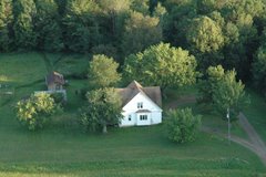
And this is what the Phillips airport, and surrounding area, looks like from 9500' above sea level. All the photos from up there looked weird, it was hazy and looking toward the sun. It was really cold up there, as well!! When I took off, it was about 60° at the surface, but cold up there. I should have put the door on.... Oh, well.

So.... Carlo is back into the logging, clearing, firewooding, etc. at the south end of the field. It's actually starting to look pretty good. I did some bulldozing (with the tractor and back blade) to get rid of a bunch of years old poplar blowdown. It worked pretty well if I avoided any obstacles, such as 1.5" diameter tree stumps......

The "woods" area is getting really thin. Starting to look like it may actually serve as a runway someday.

A few days ago, Peg and I started laying out a picket line that will define the center of the Ottertail Landing Strip. We changed the angle a little to let the south end go a little farther to the West, to better take advantage of the clearing that is evolving on the south end.

Every day of work leaves the area a little more free of brush, stumps and dead stuff. If it doesn't work out for aviation purposes, we can always make a park out of it with some picnic tables and grills.

Oh, yeah, this is what I'm talkin' about! The deck furniture is out, the grill has been in use for a while and it's actually warm enough to sit outside without bundling up. Ate breakfast out there this morning and didn't even need a long sleeve shirt.

We also now have the mambo buds on the old soft maple in the back yard. If they were spiders, I would be in fear of them.

What with the buds and a touch of green in the lawn, it's actally starting to look like spring may stay. Just hope the bugs stay away for a few months.

And the scenery just keeps impoving.
'Nuf sed....

Peg spotted this strange thing next to Spring road, about 100 yards east of Carlson road intersection. The white strips are about 8' long and are held down with some wire gizmos that look like miniature croquet hoops.

And there is a lath there with the designation: t116. No clue what they are about, but other people have seen similar markings in other areas.
F.O.O.L.S. (Friends Of Ottertail Landing Strip) will award a free plane ride to the first correct explanation of this strange phenomenon. Don't delay.....

O.K., it's warming up! Put the grill on the south side of the house to avoid that cold north wind while grillin' up some chicken.

Took a little airplane ride the other day. Here is how Phillips looks in the early spring.

A local guy maintains this motocross track in his back field. He lets anyone use it, they just have to sign a waiver when they get there. Pretty cool in these days of fanatical obsession with "liability"......

Here is a view of Cranberry Lake, Ivan's second home. Maybe first???? From about 8500' up. You'll have to click on these to see the detail, and some pics get REALLY BIG when you do that. I'll try to figure out how to control that.

And this is what the Phillips airport, and surrounding area, looks like from 9500' above sea level. All the photos from up there looked weird, it was hazy and looking toward the sun. It was really cold up there, as well!! When I took off, it was about 60° at the surface, but cold up there. I should have put the door on.... Oh, well.

So.... Carlo is back into the logging, clearing, firewooding, etc. at the south end of the field. It's actually starting to look pretty good. I did some bulldozing (with the tractor and back blade) to get rid of a bunch of years old poplar blowdown. It worked pretty well if I avoided any obstacles, such as 1.5" diameter tree stumps......

The "woods" area is getting really thin. Starting to look like it may actually serve as a runway someday.

A few days ago, Peg and I started laying out a picket line that will define the center of the Ottertail Landing Strip. We changed the angle a little to let the south end go a little farther to the West, to better take advantage of the clearing that is evolving on the south end.

Every day of work leaves the area a little more free of brush, stumps and dead stuff. If it doesn't work out for aviation purposes, we can always make a park out of it with some picnic tables and grills.

Oh, yeah, this is what I'm talkin' about! The deck furniture is out, the grill has been in use for a while and it's actually warm enough to sit outside without bundling up. Ate breakfast out there this morning and didn't even need a long sleeve shirt.

We also now have the mambo buds on the old soft maple in the back yard. If they were spiders, I would be in fear of them.

What with the buds and a touch of green in the lawn, it's actally starting to look like spring may stay. Just hope the bugs stay away for a few months.

And the scenery just keeps impoving.
'Nuf sed....

Peg spotted this strange thing next to Spring road, about 100 yards east of Carlson road intersection. The white strips are about 8' long and are held down with some wire gizmos that look like miniature croquet hoops.

And there is a lath there with the designation: t116. No clue what they are about, but other people have seen similar markings in other areas.
F.O.O.L.S. (Friends Of Ottertail Landing Strip) will award a free plane ride to the first correct explanation of this strange phenomenon. Don't delay.....
Thursday, April 12, 2007
When I read this bit, I knew that one of the anonymous commenters on this blog would not be allowed at the Olympics in China.... read a few paragraphs and you'll see what I mean.
11.4.07
News Flash!!
Warning! If you don't like pictures of dead turkeys, stop here!!!
↓
↓
↓
↓
↓
↓
↓
↓
↓
↓
↓
↓
↓

After taking a break this afternoon and posting on this blog, I saw these turkeys in the yard. One has a small white spot near the base of it's tale. Another has a large white area in the same spot.... I never noticed this marking before. Wonder if it is just a common thing that we don't normally "see".

So I went back to my hunting spot and about 1/2 hour later, two hens and this tom came strolling through. I did no calling, they were just moving through.

So now what do I do with these two vacation days I was going to use hunting??? Go back to work???? NOT!!
Later, Carlo
↓
↓
↓
↓
↓
↓
↓
↓
↓
↓
↓
↓
↓

After taking a break this afternoon and posting on this blog, I saw these turkeys in the yard. One has a small white spot near the base of it's tale. Another has a large white area in the same spot.... I never noticed this marking before. Wonder if it is just a common thing that we don't normally "see".

So I went back to my hunting spot and about 1/2 hour later, two hens and this tom came strolling through. I did no calling, they were just moving through.

So now what do I do with these two vacation days I was going to use hunting??? Go back to work???? NOT!!
Later, Carlo
Mid-week shenanigans....

Did I mention that Hailee made an appearance last weekend? She is getting around REALLY well at this point. But with a minimum of mis-adventures, I must say. She still appears to be quite jovial and maybe a little less fearful of me these days. I managed to share some Cheerios and grape juice with her Sunday morning, which was quite a change from the past. Maybe we can become friends after all.....

The clay bird event was quite a good time. Flinging the clays out over a small gravel pit (which also offered a good place for plinking with .22's) provided some space to shoot before the birds got to the woods.

Multiply this view by about 5 or 6 and you get an idea of what the ground looked like after the guns fell silent. Empty clay bird boxes were handy for holding all of the empty casings when we cleaned up afterward.

Back in Ottertail country, more birds made an appearance. This is a pair of Cardinals that have been around since early spring. I have been trying to get a photo of them out in the open, but I am never quick enough. We also have some redwings and robins(they can look miserable out in the wet, snowy weather).

Another tom turkey goes sneaking through the yard. It's amazing how the composition of the flocks keeps changing. Nine hens one day, three the next, two hens/no toms the next, etc.... I don't understand how that all works, but what the hey?

Now this bird did not show up in the yard. It's another Noble addition to the artworld, planning to be showed at the "Birds In Art" event at the Leigh Yawkey Woodson Art Museum in Wausau. Way to go, John!!

This is a random addition. I put a pic of this somewhere in this blog many months ago. It's part of the big change in the Highway 51/I39 route on Wausau's west side. I'm not sure why they left this bit of overhead road, but it was still there a few weeks ago.... go figure.

Turkey hunting starts today, Wednesday, if you got a first season permit. Last weekend I put up the blind in the little white pines in the south field. It's a little sturdier than previous ones. I had a lot of small tree parts from the clearing effort at the south end of the field. It was hard getting some of them in the ground, what with the return of the FROST!!! We're going backwards in the weather realm. Strong winds and snow this afternoon, but not like they are getting south of here. They can have it, I don't want it, it's too wet for me.

I guess it will work out. It's not too obvious and as long as those birds don't see motion, I think we'll be alright. You need to remember that as much as they want to stay alive, they are in posession of a brain that is about the size of a peanut.... I doubt that they will figure out that the nice, square wierd thing in the edge of the trees can hurt them?

No, I'm not starting any buisness... just trying to get the hang of this photoshop program. I'm sure I'm just scratching the surface, but it's a challenge that I can not ignore for some perverse reason....
Anyway, have fun at whatever you're doing, and don't do anything I wouldn't do (actually, that gives you considerable latitude in your choices....)
9.4.07
It's turkey time!!!

O.K., I have my hunting license..... I found the gun and my boots. I've been scouting for birds and this is what I saw one morning out of the west dining room windows..... we've been seeing a few more birds each year and one bunch has had nine hens and one gobbler.

Now they are on the east side of the house and the gobbler doesn't seem to eat, he just stands around looking cool....

Here he is in one of those moments when he is not all puffed up. Be sure to click these photos to get a larger view.

One morning we were treated to a fresh batch of snow and the birds showed up just the same. He looked pretty neat out in the snow, with the flakes drifting by...
I arranged to be off work this coming Wednesday, Thursday and Friday, as I have a permit for the first season which ends on next Sunday. I am hoping for a bird on the first day so I can goof off for the remaing time I have off.

I caught him in mid-gobble in this photo. It is a neat sound and especially when you're close to them. At night you can do a fake owl hoot noise and they will answer from wherever they are perched. You can then plan on where to set up the next morning. It even works sometimes...

One year a friend of mine got a bird and he let me pretend to be the hunter and get my picture taken. What a pal. These birds a big, wary and not too bright--maybe I have a chance at it.
We visited Peg's brother's house for Easter dinner. Lot's of people I see once a year, and it's always an enjoyable time. The guys usually do the first clay pigeon shoot of the year following dinner. This year I decided to actually shoot at this event, even though I have not shot clay birds for decades. It went O.K., I burned up about 125 cartridges, got a sore shoulder and had a really good time.
So wish me luck later in the week and I'll keep you up-to-date on the turkey hunt.
I gotta go, Carlo
Subscribe to:
Comments (Atom)