
O.K., it's warming up! Put the grill on the south side of the house to avoid that cold north wind while grillin' up some chicken.

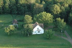
Took a little airplane ride the other day. Here is how Phillips looks in the early spring.

A local guy maintains this motocross track in his back field. He lets anyone use it, they just have to sign a waiver when they get there. Pretty cool in these days of fanatical obsession with "liability"......

Here is a view of Cranberry Lake, Ivan's second home. Maybe first???? From about 8500' up. You'll have to click on these to see the detail, and some pics get REALLY BIG when you do that. I'll try to figure out how to control that.

And this is what the Phillips airport, and surrounding area, looks like from 9500' above sea level. All the photos from up there looked weird, it was hazy and looking toward the sun. It was really cold up there, as well!! When I took off, it was about 60° at the surface, but cold up there. I should have put the door on.... Oh, well.

So.... Carlo is back into the logging, clearing, firewooding, etc. at the south end of the field. It's actually starting to look pretty good. I did some bulldozing (with the tractor and back blade) to get rid of a bunch of years old poplar blowdown. It worked pretty well if I avoided any obstacles, such as 1.5" diameter tree stumps......

The "woods" area is getting really thin. Starting to look like it may actually serve as a runway someday.

A few days ago, Peg and I started laying out a picket line that will define the center of the Ottertail Landing Strip. We changed the angle a little to let the south end go a little farther to the West, to better take advantage of the clearing that is evolving on the south end.

Every day of work leaves the area a little more free of brush, stumps and dead stuff. If it doesn't work out for aviation purposes, we can always make a park out of it with some picnic tables and grills.

Oh, yeah, this is what I'm talkin' about! The deck furniture is out, the grill has been in use for a while and it's actually warm enough to sit outside without bundling up. Ate breakfast out there this morning and didn't even need a long sleeve shirt.

We also now have the mambo buds on the old soft maple in the back yard. If they were spiders, I would be in fear of them.

What with the buds and a touch of green in the lawn, it's actally starting to look like spring may stay. Just hope the bugs stay away for a few months.

And the scenery just keeps impoving.
'Nuf sed....

Peg spotted this strange thing next to Spring road, about 100 yards east of Carlson road intersection. The white strips are about 8' long and are held down with some wire gizmos that look like miniature croquet hoops.

And there is a lath there with the designation: t116. No clue what they are about, but other people have seen similar markings in other areas.
F.O.O.L.S. (Friends Of Ottertail Landing Strip) will award a free plane ride to the first correct explanation of this strange phenomenon. Don't delay.....
12 comments:
Yeah....spring here too. wonderful day despite winds off the lake. was HOT until the wind switched and then it was tolerable. Living lake side is always an adventure. The landing strip is shaping up. 8500 feet. holy cow! that seems really high and cold!
I love the pic of that maple tree...weird. Peggy looks quite content!
the crosses are survey sites for flying over? grid out the area?
""survey sites for flying over""
Uh, O.K., but it sounds like you made that up.... what exactly is this spot telling me? The F.O.O.L.S. BoD will make the decisions on awarding the prize....
Actually, crosses like that were placed to identify found mining sites and like that there so pilots could spot them. that was before GPS i would guess.
could be osama setting his sites. hmmmm
john sez he used to see alot of those crosses from the air.
I'm going to say it marks the spot where you have to be at a certain altitude to then hit the landing strip correctly....? I love the pictures from up in the air as always! I have some really cool pictures from CA that I'll have to send to you if you want to post them....Love you
(My password suddenly doesn't work..)
Rosie
ok, now it does....
Rose, you'll have to bring the pics to Ogema and post them yourself. On second thought, that's what broke my blog last time.... just kidding. Bring them over and post.
Or would you like access to the blog to post on your own?
LOL The blog breaking is exactly why I wasn't going to say I should post them!! Let me see what things look like after I get through today and tomorrow at school and then I'll see if I can come up there soon or if I should post from over here....
The pictures are great. Cranberry lake looks great. Remembering the huge crappies we caught that day with Rosie and Bryn. Looks like spring is breaking.
Lucy
May say...??? That kinda sounds like a parade. Oh well, it sounds like you're having fun! Keep it up (CRAZY) dude! Hav HAPY day!
s.d.
Post a Comment